Rawlins County Grassland
27255 Road Bb : Ludell, KS 67730
Rawlins County, Kansas
Farm Description
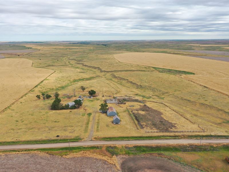
This property offers 418 acres of grassland located 15 miles northeast of Atwood, Kansas in Rawlins County. 357.8 acres in one parcel and two smaller parcels containing 33.62 acres and 26.65 acres.
Land
The grass is a mixture of short grass with good carrying capacity. There is a windmill at the old improvement site and another on the North side of Section 16. There is a nice deep draw in the grassland that serves as a travel area for the deer.
Improvements
Old uninhabitable home on property. Old grain bins and quonset. Well and electric.
Recreation
Northwest Kansas is know for its trophy class deer and excellent hunting opportunities. Located in Kansas unit 1, the Rawlins County Grassland property offers the opportunity to hunt quality mule and white tailed deer. The canyons have plenty of cover and places to hide as well as good water sources to attract multiple species of wildlife. With close proximity to agricultural fields these pastures have been know to have pheasants as well as Bobwhite Quail inhabiting the area. Property qualifies for non-resident landowner deer tags.
Agriculture
There is currently a grazing lease in place through the fall.
Water/Mineral Rights & Natural Resources
All Minerals owned by Seller will pass to Buyer. All water rights pass to Buyer.
History
In 1875, T.A. Andrews and J.M. Matheny traveled to Rawlins County and started a town site about two miles east of the current city. The city of Attwood with two t's was named after Attwood Matheny, the 14-year-old son who accompanied his father on the journey. In 1882, the U.S. Post Office requested permission to drop one t thus becoming Atwood. In 1881, Atwood became the county seat of Rawlins County.
Location
From Ludell head north on County road 739 for approximately 6 miles to road Aa, turn right and head east for 2.75 miles, turn north on road N for 1/4 mile, to road Bb, turn east on road Bb and go 1/8 mile to property on north side of the road. The other two smaller tracts will be north approximately 1.25 miles. Road N has a left hand curve, but stay on road N and tracts will be on the east side of the road.
More Farm Details
More Farms from Hayden Outdoors
 80 AC : $1.3M
 205 AC : $1.1M
 7.8 AC : $850K
 640 AC : $3.93M
 160 AC : $1.65M
 251.5 AC : $950K
-
 114.7 AC : $2.5M
  472.7 AC : $895K
 950.8 AC : $5.5M
 New263.5 AC : $2.75M
 80 AC : $1.6M
 1,222 AC : $10M


