Escape to Your Private Desert Haven
Doyle Rd : Landers, CA 92285
San Bernardino County, California
Farm Description
Call Or Text Us Now For Availability.
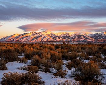
Explore a 5-acre lot in the High Desert region of San Bernardino County, CA. Landers is known for its unique desert landscape, offering stunning mountain views and wide-open spaces, and is home to Giant Rock, the world's largest free-standing boulder with cultural significance. Just 41 minutes from Joshua Tree National Park and Pioneertown, this lot offers easy access to Yucca Valley amenities.
With ample space available for development, this property offers numerous possibilities for building something exceptional. Whether you're looking to create a spacious home or establish a thriving business venture, there are countless ways to utilize this land to achieve your personal goals. Don't let this opportunity pass you by-contact us now to learn more about this extraordinary property.
Call Now Or Text Us For Availability.
Easy roll-on, roll-off access.
Photos and video of the actual lot.
Zoned for Residential, Recreational, and Agricultural Use.
Electricity: YES - Power Lines are There - Just 496 Feet away from the Property.
Primary Road: Dirt Road Access.
Water: Would be from Alternative Sources.
Call Us Now.
Cheap and Affordable Vacant Land For Sale in Landers
Rural Land in California
Developed Property For Sale With Direct Road Access
For Residential, Recreational, and Agricultural Development in San Bernardino County
Buildable Land With Power Access and Resource Energy Projects
Desert Land With Mountain Views
Land Near Entertainment Hubs
Farm and Ranch Land Ideal For Farming and Harvesting, Grazing Livestock
Perfect for Hiking, Hunting, and Rock Climbing Enthusiasts
Quiet and Friendly Neighborhood
Located Near Schools, Parks, Shops, and Restaurants
Farm Maps & Attachments
Directions to Farm
Center of Lot GPS Coordinates: 34.335383, -116.418461
GPS Coordinates for Corners of the Property:
Nw: 34.335830, -116.419568
Ne: 34.335820, -116.417350
Se: 34.334913, -116.417357
Sw: 34.334922, -116.419580
More Farm Details
Farm Price History
More Farms from Patrick Elder
 19.1 AC : $699K
- 81.1 AC : $275K
- 14.9 AC : $500K
- 6 AC : $17K
- 10 AC : $21K
- 7.5 AC : $41K
- 20.3 AC : $26K
- 8.9 AC : $20K
- 19.8 AC : $12K
- 20 AC : $48K
- 5 AC : $14K
- 19.4 AC : $12K